Flood protection
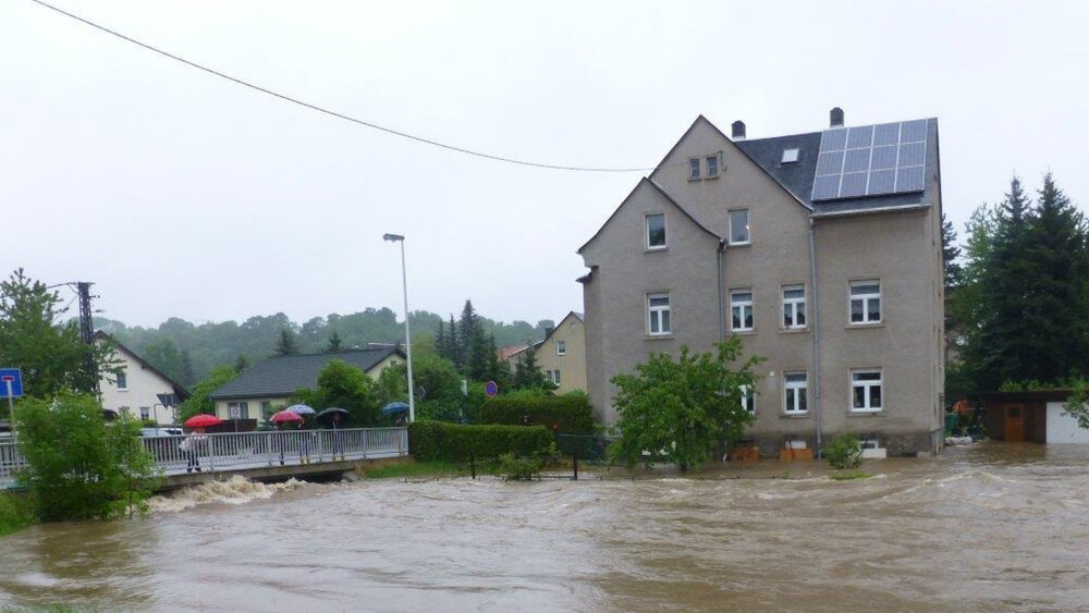
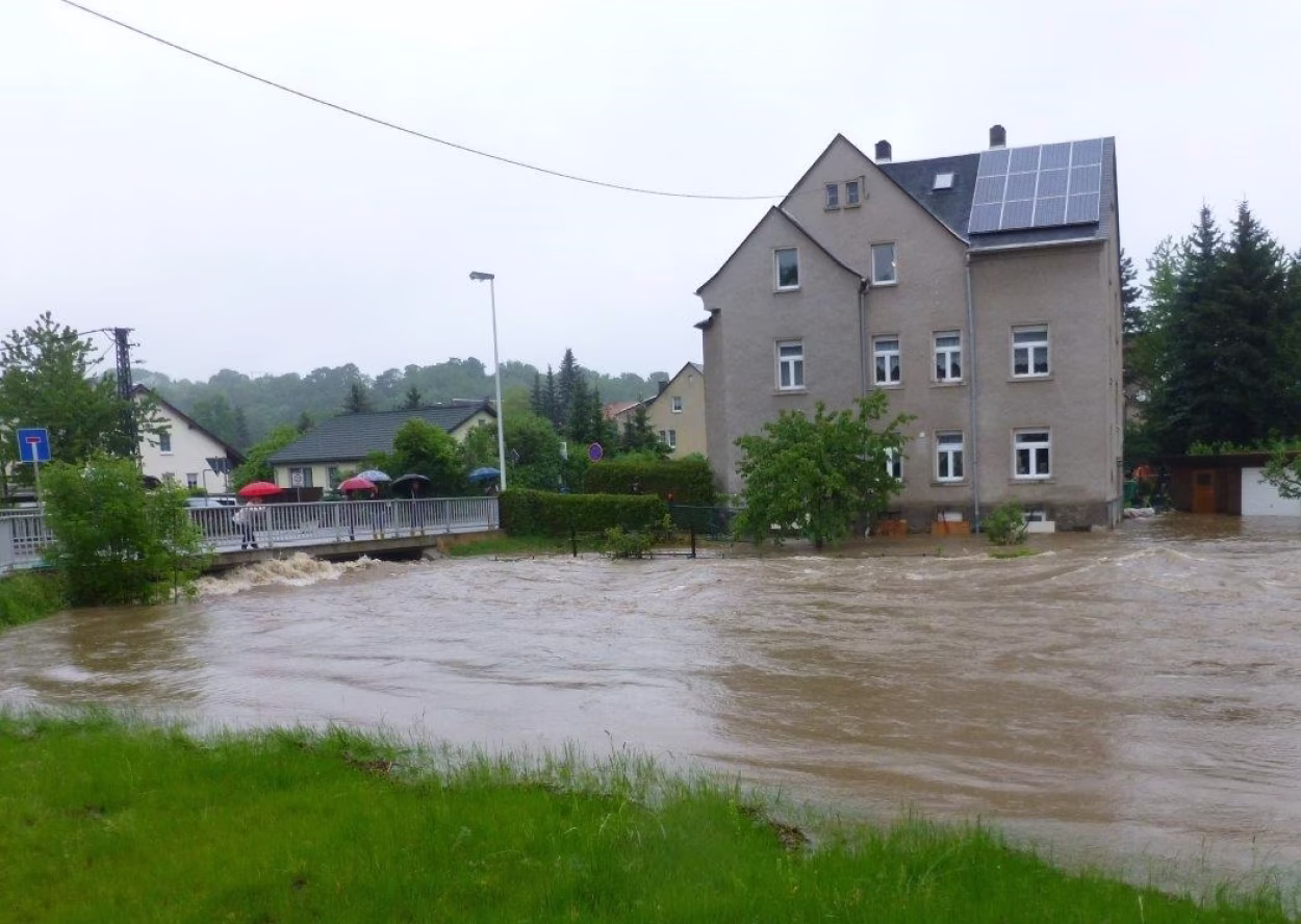
Even if the watercourses in our city do not give the impression that they pose a danger in normal times, the recent flood events in 2002, 2010 and 2013 proved the opposite and also caused considerable damage in the city of Chemnitz. Due to the historical development of the city along the river valleys of Chemnitz, Würschnitz and Zwönitz and the ever-increasing utilisation of the former floodplains, the risk and, above all, the potential for damage has continued to increase. In addition, according to current studies by the Saxon State Office for the Environment, Geology and Agriculture (LfULG), an increase in heavy rainfall events is to be expected in the coming years, particularly in the summer months, due to climate change.
Intensive efforts are therefore required to adequately protect the infrastructure and important material assets, but first and foremost the citizens. There can be no absolute protection against flooding. Immediately after the flood event in 2002, the Free State of Bavaria commissioned flood protection concepts for the 1st order watercourses, which analysed the existing flood protection and identified measures to improve it. Numerous measures have since been implemented by the LTV.
The specific requirements for flood prevention have also been expanded at a legal level in recent years. In 2007, the European Union issued Directive 2007/60/EC on the assessment and management of flood risks ("Flood Risk Management Directive")[1]. Its content was incorporated into the Federal Water Act (WHG)[2] and the Saxon Water Act (SächsWG)[3] in 2010 and its content was concretised. The flood protection concepts are currently being updated by the Free State of Saxony into flood risk management plans (HWRMPl). As part of this process, the flood hazard and flood risk maps are being drawn up and updated. The experiences of the 2010 and 2013 floods, as well as the flood protection measures that have already been completed, are also incorporated into this update.
At the same time, the city of Chemnitz commissioned flood protection concepts for the Kappelbach and, in cooperation with the city of Limbach-Oberfrohna, also for the Pleißenbach. These are regularly reviewed and updated as required.
Further information on the Chemnitz 2030 urban flood protection concept and on building in floodplains can be found on the following pages.
Flood protection concept 2030
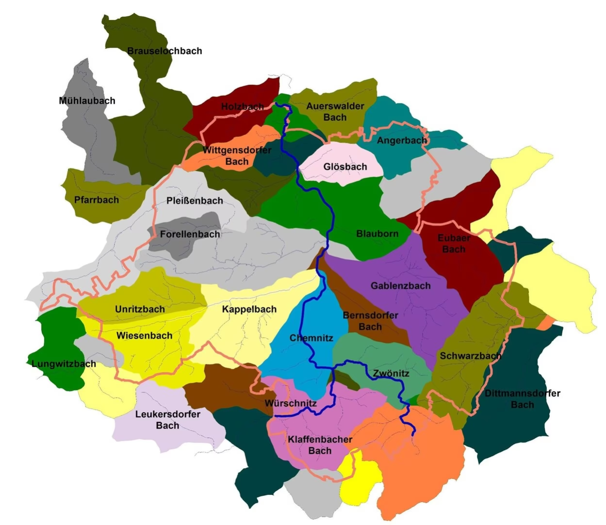
As damage can also occur to all other bodies of water in Chemnitz during flood events, the Chemnitz City Council (resolution BA-030/2013) commissioned the city administration to develop a flood protection concept "Chemnitz 2030" in 2013. One aim of this concept is to develop so-called watercourse profiles for other 2nd order watercourses in the city area in parallel to the legally required development of flood risk management plans and flood protection concepts for watercourses with an identified significant flood risk (Kappelbach and Pleißenbach).
Within this framework, an analysis of the existing risks in the event of possible flood events is to be carried out for each catchment area and thus for each watercourse, and specific measures are to be identified that can minimise these risks.
This has already been done for the Gablenzbach and the Wittgensdorfer Bach (information documents I-015/2017 and I-038/2019 to the city council), which were subsequently published. The following third watercourse profile addresses the flood situation in the Klaffenbacher Dorfbach catchment area. This will be followed by the successive processing of the municipal catchment areas of other 2nd order watercourses.
Building in floodplains
Based on the calculations of the flood protection concepts, floodplains were established on the Chemnitz, Zwönitz, Würschnitz, Kappelbach and Pleißenbach rivers. According to the legal definition, floodplains are areas that can be flooded up to a flood event that is statistically expected to occur once every 100 years (HQ100). The corresponding plans and flood hazard maps can be viewed here at any time so that every citizen can find out about their individual flood risk.
In designated flood zones, the construction or extension of buildings is generally prohibited, both inside and outside. Exceptions are only possible if strict conditions are met. Only if it can be proven that a planned construction project
- flood retention is not or only insignificantly impaired and the loss of lost retention space is compensated for extensively, functionally and simultaneously,
- the water level and discharge during floods are not adversely affected,
- the existing flood protection is not impaired and
- the project is implemented in a flood-adapted manner,
an exceptional authorisation may be granted by the competent authority (usually the building permit office). The possible impact on the neighbourhood must always be examined. It is the responsibility of the person wishing to build to prove the existence of all exemption requirements to the authorisation authority, if necessary by means of expert reports.
Detailed information on the subject of "Floods in Saxony" and flood risk management can be found on the Internet at: https://www.umwelt.sachsen.de/umwelt/infosysteme/lhwz/index.html.
In addition, a flood competence centre has been set up in Leipzig in the Free State of Saxony in recent years, which advises citizens on flood prevention, flood-adapted construction methods, protection options for existing buildings and the issuing of a flood prevention certificate.